
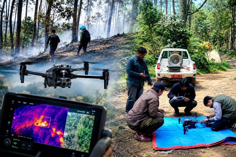
Malang, en.SERU.co.id – Managers of UB Forest are using the Matrice 30T thermal drone to strengthen early detection of potential forest fires during the dry season. The technology allows officers to spot heat points from the air and obtain exact coordinates. This approach proved effective when staff located and extinguished a fire on the western border of UB Forest between 25 and 27 August 2026.
Coordinator of Forest Area Protection and Supervision at UB Forest, Dr Muhammad Yusuf, said drone use is combined with ground patrols. When the sensor detects high temperature readings, officers receive location and coordinate data that then guide on-site checks.
“This step becomes even more important during the dry season because drier vegetation raises the risk of fire. If there is a hotspot, we go there right away to check. If we find a fire point, we put it out immediately,” Yusuf said on Monday (7/9/2026).
One fire point was detected during drone patrols on 25–27 August 2026. It was located on the western border of UB Forest, specifically just outside the UB Forest area that borders directly with other forest land.
Even though the hotspot lay outside the managed area, the team moved quickly. The fire was considered likely to spread if left alone, especially under dry conditions.
“Alhamdulillah it is still safe. No fire points were found. The team also checked again using the drone and found no additional fire points,” Yusuf said.
Detecting Heat and Providing Coordinates
Coordinator of the Education, Training and Development Division at UB Forest, Rifqi Rahmat Hidayatullah, explained that thermal drones are used to expand patrol coverage.
“We use the thermal drone for early fire detection patrols. Conventional patrols on foot or by motorcycle have limited range. We also use drones to cover a wider area more effectively and efficiently,” Rifqi said.
The Matrice 30T is equipped with a thermal sensor that lets officers identify temperature differences on the ground. Areas showing higher temperatures than their surroundings can be examined more closely to confirm the heat source.
The device also has a zoom camera so conditions on site can be observed clearly from the air. Officers can distinguish actual hotspots from other heat sources before sending a team to the location.
One detected hotspot was at coordinates 7.824301° S and 112.572614° E, at an elevation of about 1,247 meters above sea level. The coordinate data helped field staff reach the site more quickly.
“The thermal drone we use can show the exact coordinates if a fire occurs,” said Yulianto Muji Nugroho, Educational Laboratory Technician at UB Forest.
According to Yulianto, the drone also gives officers an aerial overview of the area. In a single flight the Matrice 30T can monitor roughly 10 hectares, with a maximum monitoring distance of about 500 meters.
The technology does not replace manual patrols. Drones are positioned as a supporting tool that helps identify areas needing faster attention.
Read Also:
Four Indonesian Volcanoes Erupt Public Urged to Raise Alert Levels
Limited Battery Life Still Requires Ground Teams
Yulianto noted that the thermal drone’s ability to detect hotspots has limits. One is flight duration, which depends on battery capacity.
“The thermal drone is helpful in the detection process, but its flight time is limited. One flight lasts about 30 minutes at most,” he explained.
Longer monitoring therefore requires sufficient battery supplies. Managers currently schedule drone patrols twice a week.
Another limitation is that the drone only covers detection and monitoring. When a fire point is found, officers still must go to the site to extinguish it.
UB Forest’s mitigation system therefore combines aerial drone eyes with ground response. Drones help locate the site while officers confirm conditions and take action if fire is present.
Involving Communities and Farmers
In addition to technology, UB Forest managers treat the surrounding community as part of fire prevention efforts. Education is given to residents and farmers working near the area, especially about the dangers of using fire to clear land during the dry season.
“Communities need to raise their awareness of activities that could start fires. We also urge people not to burn land carelessly and not to leave fires until they are completely out,” he said.
Managers also involve tenant farmers through Cooperation Agreements (PKS). This involvement is expected to widen the monitoring network because the farmers live and work around the forest area.
“If there is an incident such as a hotspot or a fire, we hope everyone can help each other,” Yusuf said.
According to Rifqi, technology is only one part of mitigation. Fire prevention still depends on the care of people who are present around the area every day.